This was my second time to do an orienteering course on this map. As far as I knew, this was the only orienteering map in Chicago area that had steep hills. Chicago is a flat land, so having steep hills in this place is quite special.
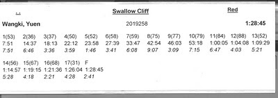
When I came here first time, I did a green course and turned out to be the first place finish. Now I came back and did a red course, and I did not do badly, either. I got the shortest time of all the red courses that I had done. My current goal was to finish a red course within 1 hour 30 minutes, and this was the first time I achieved it.
I arrived late and the parking at the start/finish point (Cherry Hill Woods) was full. Unfortunately, I had to drive 1 km north to park at Teason’s Wood and followed the markers to walk back south. Therefore, I got some warm-up before I started the course.
Finally, I arrived at the event center.
After I got the map, I felt that I had time to find some geocaches nearby before starting the course. I had many caches to find in the nearby area, so I thought I should find a few before starting the orienteering course. Seeing that the approximate locations of the geocaches would not spoil the course, and I had some time before the start closed, I finally found 3 caches near the start points.
After finishing the orienteering course, I found some other caches. However, they were outside of this map so I would not mention here.
Now get back to the main course: the red orienteering course. The map, my route, and my split times were shown below.
I wondered what made me do well in this place for two times. My guess was that this map is relatively easy to navigate, since there were many handrails on the map (e.g. paths, streams). The re-entrants were also mostly clear.
I would separate the course into several sections and pick several controls to talk about in order to keep the blog short.
Control start-5: There is nothing much to say about the first 5 control points. At the beginning open land, some burning had happened that made the area look black (see picture below). I travelled through the forest to find the lake. After meeting the main path, I used the indistinct stream as a path to get to the open area. The next few points had clear paths to lead me to or close to the controls. I made a mistake in control 4 and identified the wrong re-entrant. The purpose of control 5 and 13 was to force us to use the underpass, since the road above is a major roadway.
Control 5-7: Control 6 and 7 were also easy. The re-entrant to control 6 was clear. In control 7, I used the major trails most of the time to get to the control. I just needed to be careful in counting the bends on the trail. Perhaps an alternative route was to go more south to the road and use the road to lead to control 7, but you had to go downhill and then uphill. Running through the forest seemed not to be a good idea because the forest was not easy running and there was a re-entrant to climb.
Control 7-10: I felt the most challenging decision was control 7-8. I was not sure if there were any better routes. I used to road and then the major trail north of control 8. Then, I needed to know where to bend south from the road to the control. It appeared to me that using other trails to get to control 8 was too dangerous. In fact, I felt that this section was one of the more challenging sections of the course. I was also not sure how to professionals would run from control 9-10.
Control 10-13: The river might get my feet wet in this section of legs, but the navigation by re-entrant, river, and paths was not a problem. I also wondered: are there any better routes than my choice?
Control 13-finish: This was another section of the legs that I could consider challenging. It was at the end of the race. From control 13-14, one had the climb the hill. Then, the rest of the controls were quite short and in a re-entrant system. The section seemed to test my concentration when I started to feel tired. In control 14-15, I tried to run as straight as possible (i.e. not following the path), but avoided the drops at the re-entrants. In control 15-16, I had to get across the main re-entrant. In control 16-17, I used to path to get close to control 17.
Therefore, Perhaps I could finish to course under 1 hour 30 minutes because the course was relative easy.
When I came back, I met Rich Gaylord again. He gave me an orienteering map in Danville, IL (about 30 minutes drive east of where I am) that he ran in 1970s. It was nice to see how the map changed after many years. Therefore, I had a reason to continue to run orienteering courses in Chicago, since I had to return the map to Rich.


No comments:
Post a Comment