Tuesday, November 23, 2010

Sept 26, 2010, Poplar Creek, from Chicago Area Orienteering Club (CAOC)

Poplar Creek marks my first orienteering experience since my college life.  Two years ago on November, I was with a person from UI to attend an orienteering event in Poplar Creek because he liked orienteering, and I was also interested in this.  I even brought two more people from Chicago to come, with one of them my friend and another person my friend’s friend.  I remembered that day was cold with flurries.   I also remembered that I did the Green course (advanced short course) for my first time in orienteering, and I managed to finish it.  By that time, I was very confident with my map reading skills, and I had no fear to run into woods.  Perhaps I already liked orienteering when I was young.  It was just that I did not find the correct opportunity to do it.

Now I came back to this place once again.  This place was far northwest of Chicago.  I once again did not use I-57 to go to Chicago area and use IL-47 instead.  Then, I used I-55 and then drove IL-59 all the way from the south to the north.  This avoided all the toll highways (I-88 and I-90).
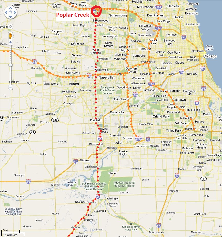
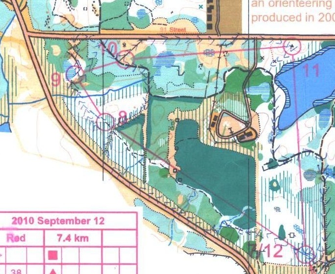
Red:  shows my way to Poplar Creek
Orange: toll highways in Chicago

I continued to do the hardest and longest Red course.  The map, the clue sheet, and my results are shown below.  The map is huge so I decided to scan only the area with the course.  The clue sheet is scanned separately.


From my last Poplar Creek experience, this location has many open areas with a lot of tall grass.  The grass certainly will slow down people in running these areas.

I met Richard Gaylord, the course setter who designs the route of the orienteering race, at the start point.  He was experienced in orienteering.  When I mentioned my interest in organizing an orienteering event in Champaign, he told me his experience ~30 years ago when he did orienteering in central Illinois area.  He was amazed with the terrain.  He would even like to bring his old maps to me next time we meet.

Rich set the course such that all control points were on the south side of Golf Road.  This action was to avoid the participants from crossing a road where vehicles travel 50 MPH (80 km/h).  Because of this, to me it was the first time that the registration and the start/end point were at separate places (see map above).

After I finished this course, I felt that I made so many mistakes.  One orienteering term in my mind is “parallel error”.  Nevertheless, it was better than last time in Waterfall Glen East (see here) that I lost almost an hour for finding 2 controls.

The followings are my review on each control:

Start à 1: I already made an error in the first leg.  My plan was to run the trail to a marsh.  Then I used the marsh to maintain the approximate running direction, so that I would hit the open land.  Finally, I used the boundary between white wood (easy running) and yellow open land and got close to Control #1.

What actually happened, however, was that I knew I ran too far because I saw another open land ahead.  However, I wanted to find where the first open land ended because that point was the closest feature to control #1 (see map below).  I walked back in general direction, not completely aimless but also not having accurate bearing, and searched for the control.  Fortunately, I found the control when I walked back.


1 à 2: I think I did well on this one.  I ran back to the trail and followed the trail until I got close to the white wood.  Then I ran into the forest and found the control.

2 à 3: Use the trail and then go west into the wood.  Notice the contours to locate the hill.  No problem with this leg, either.

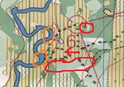
3 à 4: I had to make some decisions for reaching this control --  I could set my bearing straight to control #4, but I would pass through the wood in dark green (difficult to walk through).  The other option was to go west to the open land so that I could move faster than in the woods.  In the end, I took a detour to the open land on the west, and then went back east to another open land.  From there I used the compass to point to the control #4 direction to run.

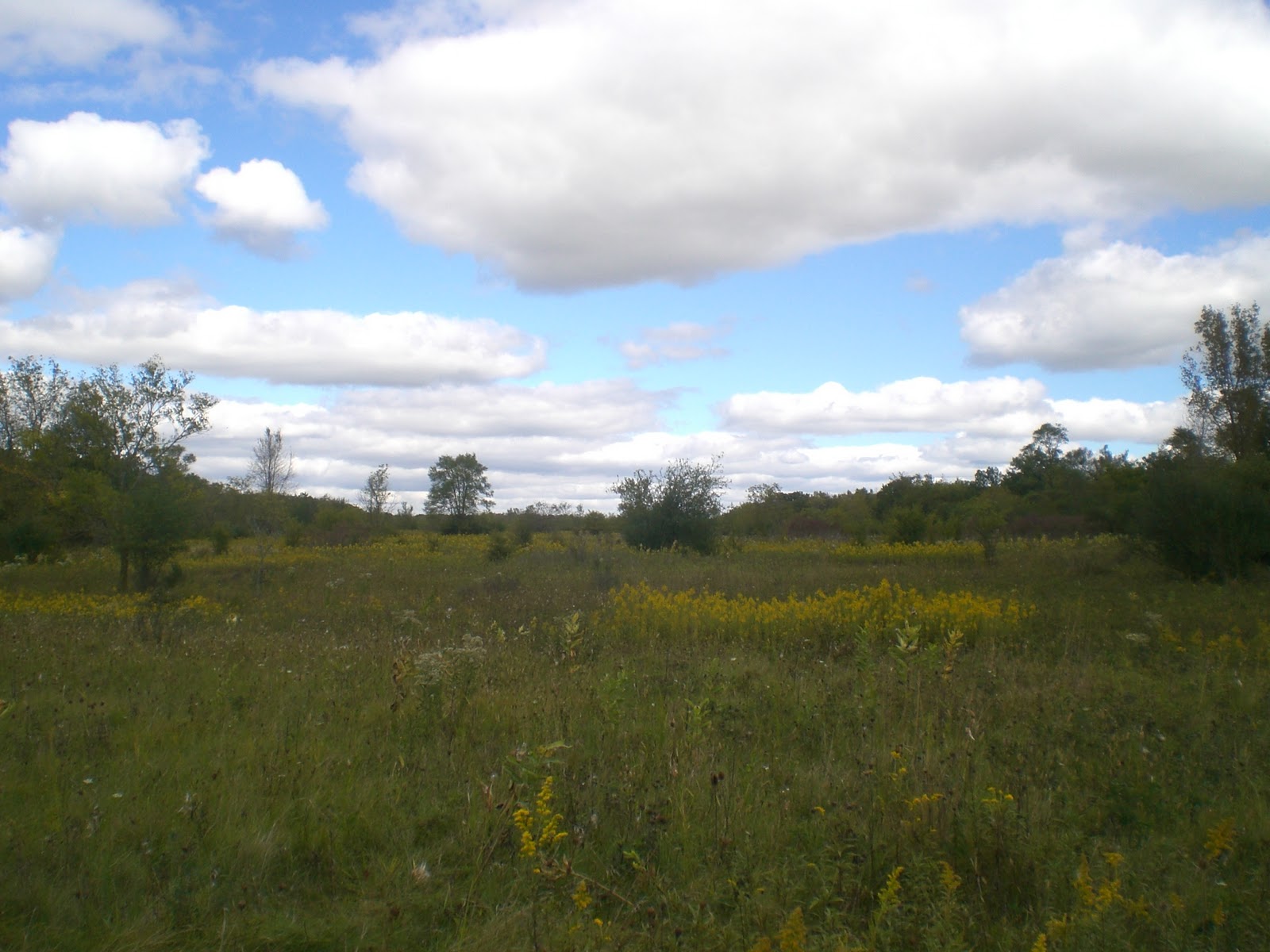
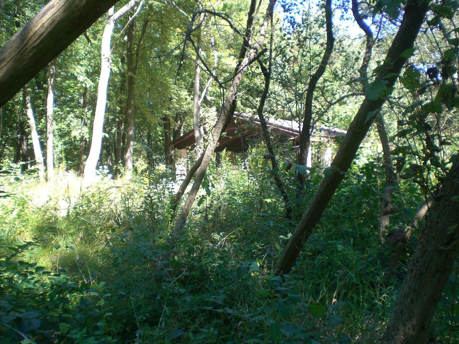
The east open land on the way to Control 4, looking east
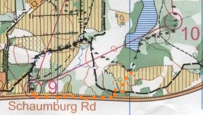
After finishing the course, I talked to Richard about how I progressed to each control.  For this control, he commented that perhaps it would be faster if I ran the trail on the west open area until control #4 was east of me. Then I went east into the white wood and got to the control.  That was a good suggestion after I thought about this.
Blue: straight line route,
Black: my route,
Orange: Richard's suggestion,
Red arrow: Picture taking location and direction of the above picture
4 à 5: Nothing too special.  I used the trail, then I used the compass bearing where the trail ended.  I found the control without any difficulty.

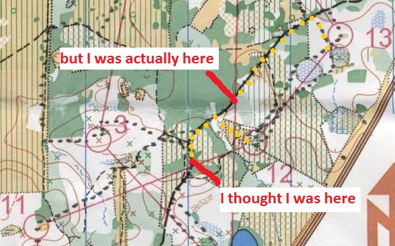
5 à 6: Error number 2! I considered myself making a parallel error on this one.  A parallel error means that a person think that one has reached the feature (e.g. a bend of a stream, a distinct tree), but one actually reaches the wrong feature because the correct feature is close to the wrong but similar feature (e.g. at the wrong bend of the stream segment).

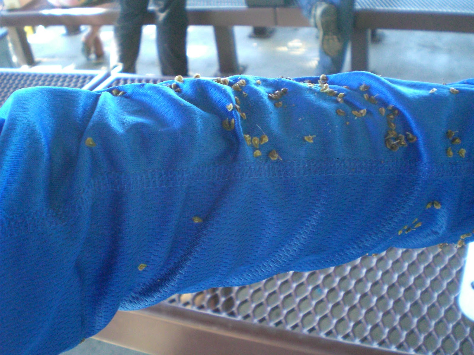
My parallel error occurs when I got close to control #6.  I looked at the wrong vegetation boundary.  This area had a lot of tall grass, and it was quite difficult to walk over grass.  There were some trees in the middle of this open land, which I might assume these trees would be drawn on the map as “distinct trees”.  Moreover, I had to visit the river on the west to count the number of bends.  With these clues, I finally recognized my location and found the control #6.
1) I thought I was at small red circle (a small corner of vegetation boundary)
2) but I actually viewed the big red oval (larger vegetation boundary)
3) the two river bends (in orange circles) helped me to relocate myself
4) red arrow shows the picture taking location and direction of the picture below 
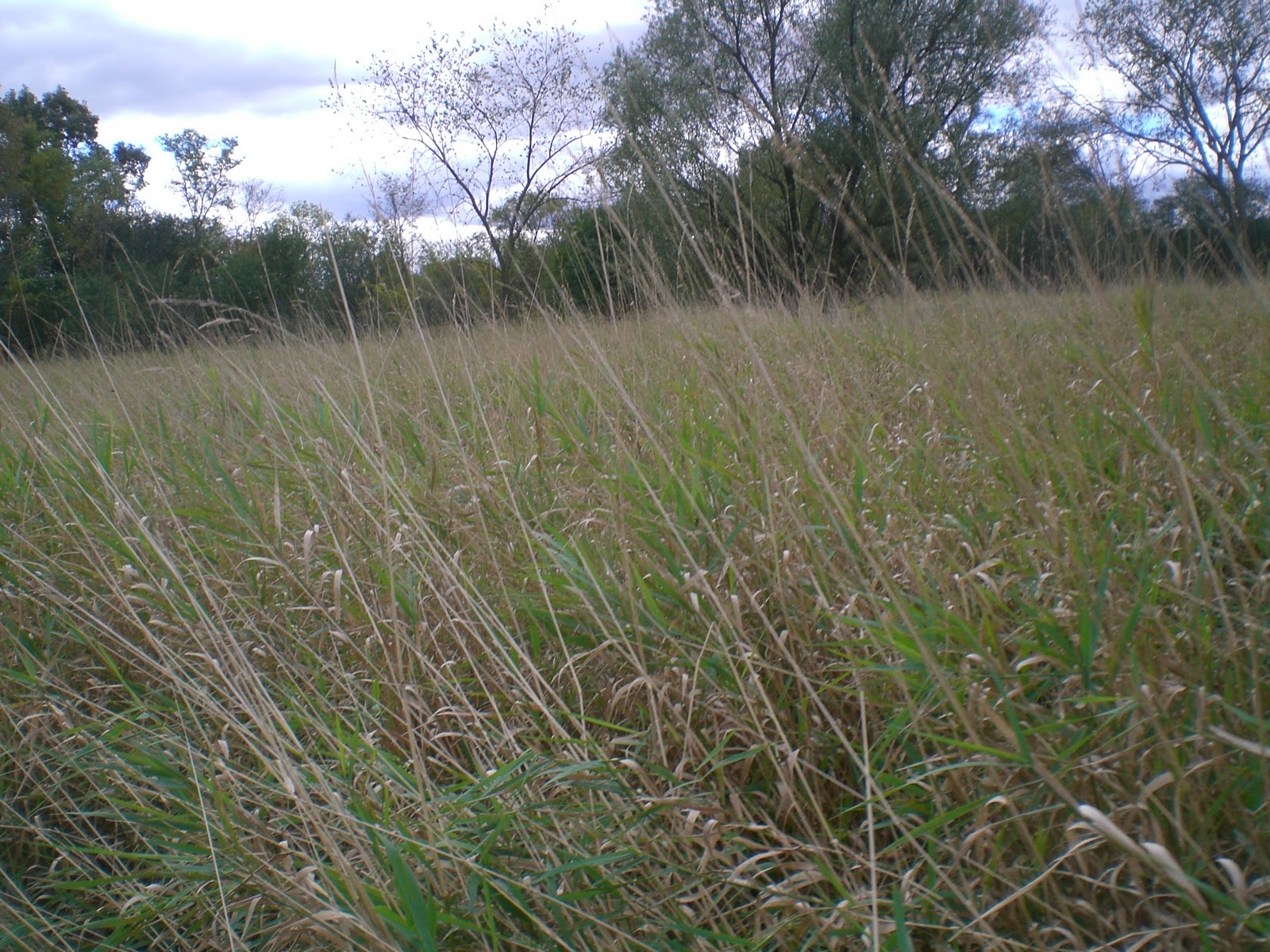
Tall grass

6 à 7: Compass bearing helped me enough to find Control #7.

7 à 8: A lot of running across the grassy open field.  There was a dry stream that I could follow and pass through the green wood.  Then I reached another open land and found control #8.

8 à 9: Running through the trail almost all the way.

9 à 10: The trails can be used for the most part until I got close to the control, where compass bearing was used.  After finishing the course, Richard suggested that I could also run along Schaumburg Road so that the running distance could be shortened.  How come I did not think about that!

10 à 11: It was once again a compass bearing exercise for me.

11 à 12: Error number 3!  Perhaps I was off-guard by this control, thinking that the major trail that I previously passed through to control #2 should readily locate myself.  Therefore, I ran east without thinking much until I hit the major trail.  However, I identified myself on the trail at the wrong place.  This was another parallel error.  I used the bending of the trail to identify my location, but I incorrectly locate the bend.  The result: I went to a big marsh after going off-trail.  I was confused for a minute and then realized that I was close to control #13 rather than control #12.  Time was wasted in going back to Control #12.
Yellow dots show my plan to approach Control #12.  I should get off trail after the trail bends right.  However, I did not estimate my starting position on trail correctly, so a big mistake was made.
12 à 13: Using compass and marshes to lead me back to Control #13.

13 à 14: Running along the vegetation boundary and then using the compass and surrounding contours to lead to control #14.

14 à finish: Running mostly on trail.

Friday, November 5, 2010

Sept 18, 2010, Robinson Park, from Illinois River Valley Orienteering Club (IRVOC)

1.      The event

I drove 2 hours northwest to Peoria, IL to participate this orienteering event.  The weather forecast was scary.  There would be heavy thunderstorm in Peoria around that time.  However, I still decided to go because there should be some break of heavy rain.

While I was driving on the day of the event, I could see that the patchy dark clouds gave some ominous feelings about bad weather.  However, the real threatening weather came when I got really close to Peoria.  Super dark clouds, lightning, and heavy rain were all there when I arrived at downtown Peoria.  Look like this orienteering would be muddy.

I had done orienteering under heavy rain and thunder before.  In April 2009, I was in Chicago Busse Woods.  The weather was the worst for outdoor activities.   Adding to the fact that Busse Woods has a lot of marshes, the entire body was wet after finishing an orienteering course.  I still remembered that one control was in the middle of a water-filled depression and one could not reach that without getting the feet wet.

Fortunately, the rain got lighter when I arrived at the start point.  When I started the course, the rain virtually stopped and only a few thunders were heard.

This is a brown course. In the US, the advanced course can be in colors of brown, green, red, and blue.  Brown is the shortest.  Green is the second shortest.  Red is the second longest.  Blue is the longest. The difficulties of these four color courses should be similar.

Although orienteering events in Peoria are usually small scale, the area can sometimes be hilly (as evidence by many contours) with a lot of easy running forest (“white forest”).  This makes the orienteering event challenging.  Chicago has several large forest areas, but the terrain is generally flat.

Going back to this brown course, this is a course that is 4.6 km long and has 225 m climb.  I used 1:43:16 to finish this course.  A traditional punch system was used, so there is no split time available.

Overall, although the course is relatively short, it is challenging.  Some legs provide route choice questions that I could not answer immediately.  There was a control that was wrongly placed, and the course setter admitted that, but that did not ruin the fun of this course.  One more good news: there was no heavy rain when I did this course.  The forest was foggy at times, though.

My control-to-control comments:

Start à 1: I probably had not warmed up yet.  I did not see the trail on the map (see red dotted line in the map).  Instead, I went into residential area and went down slope into the forest to meet the trail.  I can certainly do faster for this control.

1 à 2: The compass lead the way.  The spur between control #1 and #2 tracked how far I had run.

2 à 3: I did not even need to use the compass.  I could run along the ridge of the hill and keep running straight when going downhill.  Using compass is actually slower than using identifiable features to locate oneself and decide running direction.

3 à 4: I almost used straight line distance to control #4 because there was a hidden trail along the way.  I could also count numbers of re-entrants (i.e. opposite of a spur, some says it is a valley, but orienteers like the term re-entrant) to get to control #4.  Another route choice could be following the river and going up along the re-entrant (see red dotted line in the map). I  did not know if the alternative choice would be faster.

4 à 5: The control was placed at the wrong place! The leg to control #5 was short, and I was sure I was at the right location by looking at the contours.  I saw another person doing the same course, and we helped together to find this misplaced control.  The approximate actual location of the control was marked in the map.

5 à 6: Follow the river and pay attention to the number of re-entrants passed.  If I am not careful enough, I may run too far away and I could not see any features that can tell me that I ran too far away (i.e. lack of catching features).  I had to praise that this control was well-hidden.  I did not see the control until I was a meter away from the control and looked down from the top of the gully.

6 à 7: Climbed a lot of hill and then went down a lot.  The bending of stream helped me to locate myself.  A physical leg.

7 à 8: I used a compass to set an approximate bearing so that I could meet the trail.  Then I ran along the trail and went off trail to the west after going downhill.

8 à 9: An exercise of running with compass bearing.  Not too bad.

9 à 10: Another compass bearing exercise.  Perhaps I could just use the contours to lead myself.

10 à 11:  I went back on trail and ran most of the trail.  Then I ran off trail to get to the edge of deep valley area.  I somehow walked too far away, but I finally found the control after backtracking.

11 à 12:  This is my favorite control of this course.  It was a route choice question: should I go straight line distance to control #12 so that I had to cross the deep valley and face a lot of undergrowth, or go west to use the trails almost all the way (see red dotted line in the map)?  It was a hard choice for me, but I eventually decided to go for straight distance, since I like climbing up and down and I did not see a lot of undergrowth in my eyesight.

The post-orienteering review told me that I made a bad choice: after making through the deep valley, the undergrowth turned out to be a lot of thorns and sticky seeds.  I also could not go fast in this area.  After this orienteering, I had so many seeds to take out of my clothes at home.

12 à 13 à14àfinish: These controls were completed uneventfully.


2.      Miscellaneous

a.       Devices that track orienteering progress

After finishing the brown orienteering course, I met a person who owned a very nice video camera that one can attach it to the person.  He used the camera to record what he had done during the entire orienteering course.  He also gave me the brand name of the video camera so that I can search online.  The link is the following: http://www.goprocamera.com/products/hd-hero-960-camera.php.  I think if I have money, I would like to get one (this product costs ~$180 USD).

If I have a GPS in my pants, perhaps I could track my entire orienteering route.  This way, I could track down how I got lost in the woods.

b.      Geocaching

I only picked up a geocache from Robinson Park (see above map).  I also picked up some geocaches along the drive between Champaign and Peoria (see the map below).

Thursday, November 4, 2010

Sept 12, 2010, Waterfall Glen East, from Chicago Area Orienteering Club (CAOC)

      1. The event

On the day of my sister’s birthday, the fall season of orienteering began.  In the first trip, I paid a visit to southwest Chicago to run in another map that I have not been to – Waterfall Glen East.  Here I will only focus on the event itself.  There are many miscellaneous items to talk about before, during and after this event.

This is my first time to do a red course in Chicago.  It is the longest advanced course that is offered.  I hope I can get maximum experience in the wood by doing the longest course.  The length of this course is 7.4 km. See the map and result below.

Waterfall Glen East 2010, Red Course
My split time

I took a few pictures at the starting point to show how the orienteering events are organized in Chicago:

Start point (outside)

Start point (inside)

e-punch system 
This course puts the first 6 controls on the south side of the map, and then another 6 on the north side of the map.  I did not have many memorable events in the first 6 controls because I can use roads, paths, or streams to lead to most of these controls.  The followings were my plan to tackle each of the control on the south side:

Start à 1:  Run open land at all time.  Use the main roads.  Use compass to locate control #1 when I got very close to that.


1 à 2:  Use the stream to go back to a trail.  Run along the trail until I went to a building, then use compass to lead the way.  Use the intermittent stream and contour to check how far I had run. (Note: using the indistinct path may shorten the route, but I cannot guarantee that I can find the path.  I decided to not take risk to increase my confidence of the area).

2 à 3: Go back to stream and use the stream to get on a road.  Run along the road and path until I got close to control #3.  Then use compass to lead myself to the control.  (Note: I got a little bit lost when I used the compass.  Fortunately, the small path at the far end as well as a distinctive re-entrant (i.e. a valley) helped me to reorient myself.  I finally found control 3 without losing too much time (perhaps I lost 10 minutes because of getting lost).

3 à 4: A short leg.  I can run to the path on the south and then reorient myself to find control 4.  Easy.

4 à 5: Use the trail all the way.  The part did help me to practice running.

5 à 6: Run the path for most of the time.  Pay attention to the major trail.  This is also an easy leg.


My major problems concerned with the controls in the north part of the map.  I certainly killed myself when going to control #8.

6 à 7: The orienteering nightmare began after I crossed the north half of the map.  I did not look at the compass and ran west instead of north.  I wasted time at open land area.

7 à 8: This is the feature story of this orienteering experience.

First I hoped that I could find the indistinct path.  It was unsuccessful, so I went back to the road.  I knew that I had to run quite a distance before I dug into the wood again.  Where I should go into the wood is a question.

Perhaps I should identify the bend of this main road?  The bend of the road is too gradual.  There were actually a driveway and a small structure on the west side of the road that should be really helpful in orienting myself.  However, as you can see from the map, the driveway and the small structure were not shown in the map.
Map from satellite picture (courtesy of Google Map) 
Orienteering map
Therefore, I entered the wood inaccurately at the place where the road started to get bent.  I hoped that if I went too far north, the stream above control #8 could warn me that I went too far north.

It turned out that using the stream as a catching feature (i.e. warning sign that I went too far) did not work out.  When I reflect what I did, I think the stream was dry and the stream looked like a major path.  In the map perspective, at the area a little bit south of control #8, there was a narrow clearing that I considered that as a possible path.  Therefore, I continued to go north to search for control #8.  I did not realize that I made a parallel error (i.e. I mistakenly identify my current location because I incorrectly identify the geographical features).  In the end, I went to the road in the north, and I knew that I wasted too much time on this control.

So I went southeast through the trail, spotting control #10, and then went south off trail through the narrow clearing.  Then I went southwest of the narrow clearing at a fork so that I could get close to control #8 again.  However, once I got into the wood, I still could not find this control. Eventually, I went back to the major “path” on the north, and at that time I finally realized that this “path” referred to the stream on the map.

I went south from the road and found the narrow clearing to search for control #8 again.  I saw two other people were searching the same control.  I thought I finally found the control indirectly from their help.

Even though I had so much difficulty in finding this control, I still thought that the location of the control was correct.

8 à 9: With this huge mistake in finding control #8, I guessed I should be familiar with northwest area of the map and should have no difficulty in finding control #9.  However, I once again went too far north and got on the road.  Therefore, I had to go south through the open land to get back to the marsh in order to retrieve control #9.

9 à 10: I knew how to get to it after the major control #8 mistake.

10 à 11: I already knew that I did not do well in this first red course, but let’s try to finish.  This control was easy, which was running on the road most of the time.

11 à 12: Another leg that practice running on a path.  Everybody should know that taking the straight line distance is not always the best bet.

12 à finish: I had run on this part before.

My first red course took me 2 hours 9 minutes to finish.  I guess I can consider this to be a time below average for me.  However, perhaps I should do several more red courses so that I can feel my average finish time.

Overall, I think I ran trails for the most time, so the red course was just long and not as hard as I thought (except control #8).  Perhaps this area has too much forest area that is not easy running (indicated by a lot of deep green on the map).

Moreover, I probably spread a lot of seeds along the course (see picture below).  This is probably the characteristics of orienteering in the fall.  Besides these spiky seeds, we also have spiky thorns.   Thorns had pierced me many times, but as long as I had fun in orienteering, I did not care.


2. Miscellaneous

a. Geocaching

To increase the treasure hunt experience, I began to do geocaching on my way to Chicago, after the orienteering event, and on my way back to Champaign (where I live now).

What is geocaching? There are millions of secret containers hidden somewhere in the world.  Each container has its associated GPS coordinates.  Your job is to copy down the GPS coordinates from the geocaching website (e.g. http://www.geocaching.com/).  Then use a GPS device to locate these containers.  There are usually log papers in these containers so that one can write down what date the person has visited the containers.  Some larger containers also contain some items.  You may check http://www.geocaching.com/ for more details about geocaching.

On this day, I used an alternative route to go to Chicago.  Instead of I-57, I drove to Mahomet and used IL-47 to connect to I-55 so that I passed through western suburb of Chicago.  There were 4-5 geocaches that I planned to search along IL-47.
The road to Chicago. Xs approximately mark the spots of geocaches that I found.
Then, I had two geocaches to find within the orienteering area.  I marked the approximate locations of these two geocaches on the map, too.  I met another geocacher who would like to find the same caches, so we searched together.
Xs approximately mark the spots of the geocaches that I found
As a side note, I knew that my cousin just came to the US to do an exchange program for a year.  She was placed somewhere in Chicago that was very near to where I was doing orienteering (i.e. Bolingbrook).  At this point, however, I would not find her so that she can gain maximum experience in living with a host family.  I should bring her to Champaign sometime later in the school year.

There were some people in Chicago to meet after orienteering.  There was also some dinner time in Chicago.  I went back home in Champaign late in the evening.