Thursday, June 16, 2016

May 7-8, 2016 Ontario Orienteering Championship (short summary: a lot of fun, but not good runs)

(I started to write this a week after this orienteering event, but other matters made this unfinished. After a month, I just wanted to finish this without giving too much thoughts...)

Prologue

One day, Jan from Czech Republic said hi to me, asking if I am interested in the Ontario Orienteering Championship in early May. Jan once helped me a lot in maintaining the new university orienteering club in the University of Illinois, but he left two years ago after his exchange ended. Before we parted, we went to Florida for a fun trip and did an orienteering there. We learned that in Florida, off-trail choices could be scary, since we met numerous snakes. Jan even met an alligator before.

Now, he stayed in Toronto, asking me if I could visit him. Yes. The drive was long (10 hours one-way), but from my spying of Ontario maps, I would enjoy navigating through this area. He even told me that Canadian dollars were very cheap now. Thus, I participated this orienteering championship and the road trip.

(Side note: he showed me a Toronto park map that he set the course with and asked me opinions on route choices. The map looks nice as a city park!)

On May 6 (Fri), I rented a car for this long road trip, stayed at a friend's place in Michigan for a night, crossed the Canadian border the next day, and arrived at University of Waterloo area.

Middle Distance

One and a half hour before the first orienteering event, I felt very hungry in the car. Thus, I went to the rest area for a burger meal. It filled up my stomach, but I made a big mistake for not drinking enough water.

When I got to the race venue, my start was within 30 minutes. While I managed to carry basic items for orienteering (plus the GoPro camera), I did not realize the need of water before the race. Before starting, I was excited to see a new map. When I actually got started and saw the map, I was still happy that I went to the right place to challenge my orienteering skills:


The map has a lot of contours to play with. The small map makes this a great middle-distance orienteering location, where the test of navigation skills is the focus.

Unfortunately, I felt the roughness of navigation at the beginning. To #1, I could not navigate at the correct angle, and needed the trail to reorient my direction. To #4, I made the wrong trail choice. To #5, my angle of attack deviated again. To #6, I walked back and forth to find the right gully (re-entrant).

After finding #6, my mouth started to get very dry. I started to feel that I just wanted to survive in the course, and started walking. Then, controls were not too difficult to find, but I lost the competitiveness.

Still, I overshot at #16, climbed to the highest point when going to #19 (I thought of using the ridge to reduce the climb), and to the finish, I was attracted to the wrong control next to the apartments.

Finally, I finished.

Photo by Sid (the photo taker of this Championship)

To show that I did not totally rely on my GPS watch to recall my route, I drew on the blank map first. Then, I overlaid the GPS data on the map:
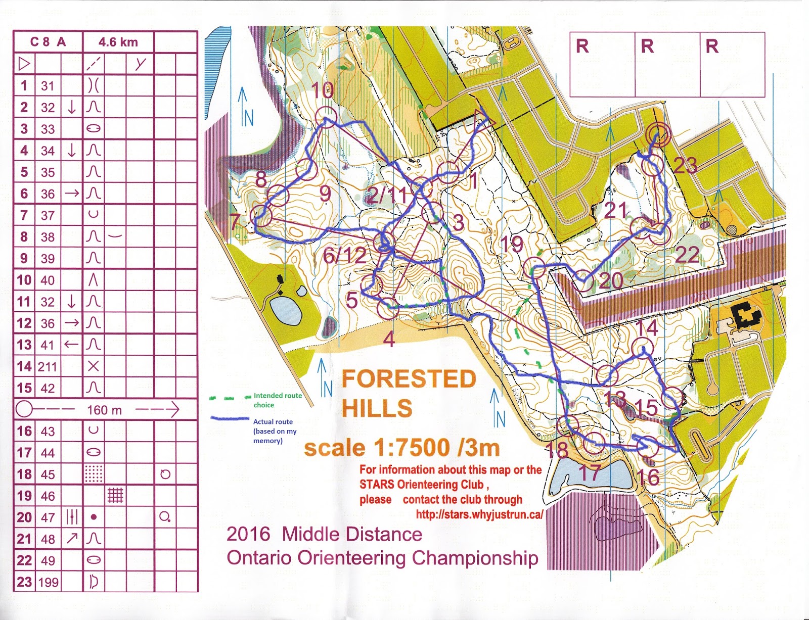

Here is the GPS data. I think I forgot how I went from 12 to 13, thus I made such mistake on my hand-drawn route.
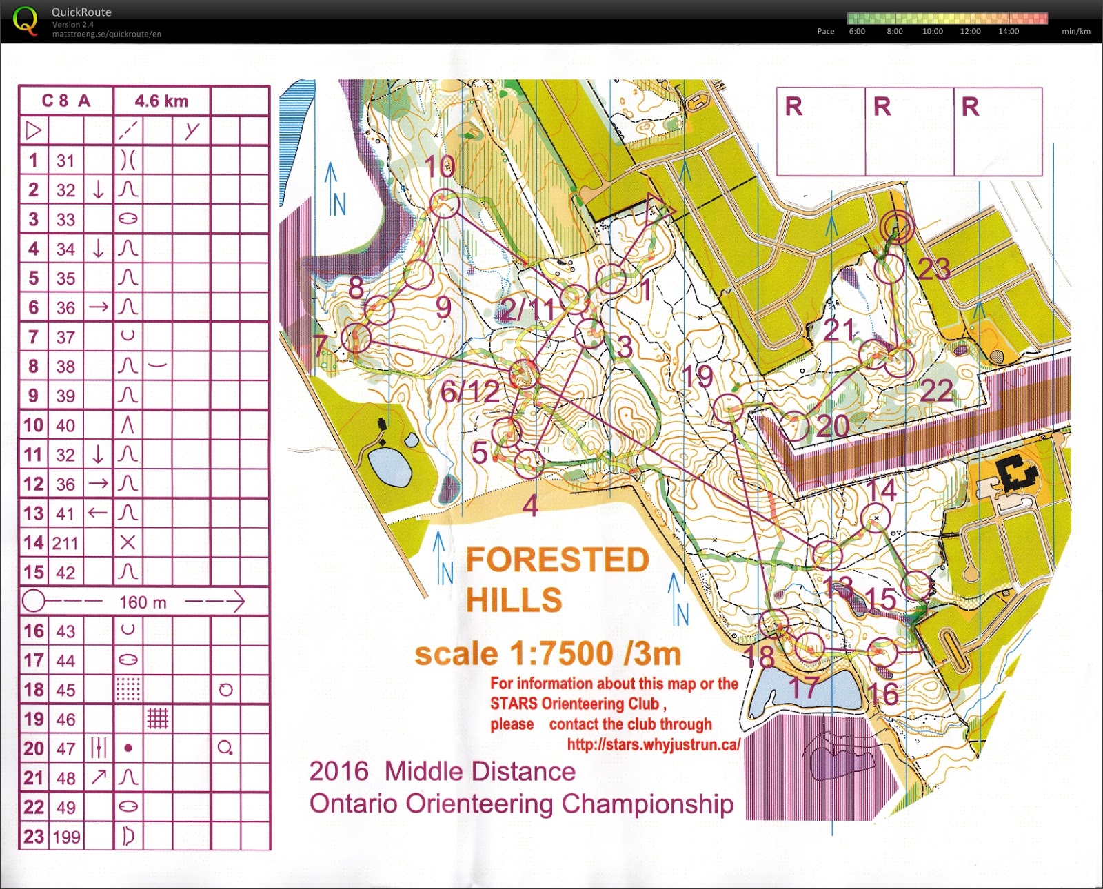

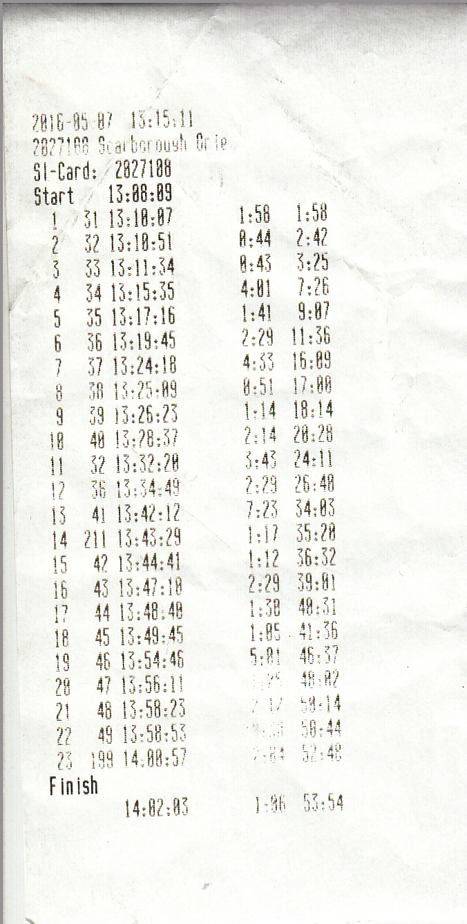
The result was not worth mentioning...

Below is the video:


Sprint

The sprint was about two hours after the middle distance. The sprint occurred at University of Waterloo, which was <10 min drive from the middle distance course. I had been here before, but it was > 8 years ago.

I was the first to start. Still, I had some time to prepare because there was a 20-min delay in start times. Before starting, I took a picture with Jan.


This time, I was well hydrated, and I could run as fast as possible. When I got started, I found a troublesome leg for Control #1-#2:
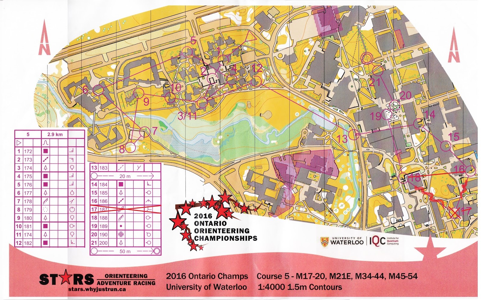

This is probably the hardest leg of the race. Finding the shortest route to #2 took time. I overshot when going from #3-#4. I thought even if I overshot one block, at least the second block should have an entrance to pass through. However, the second block was not passable. I think there is a mapping error there.

After #4, things went smoother. I could find the best routes without much of the problem. There were still detours from point to point, but the choices are just either go right or left.

I did find this sprint was fun.

Here is my hand drawn route:
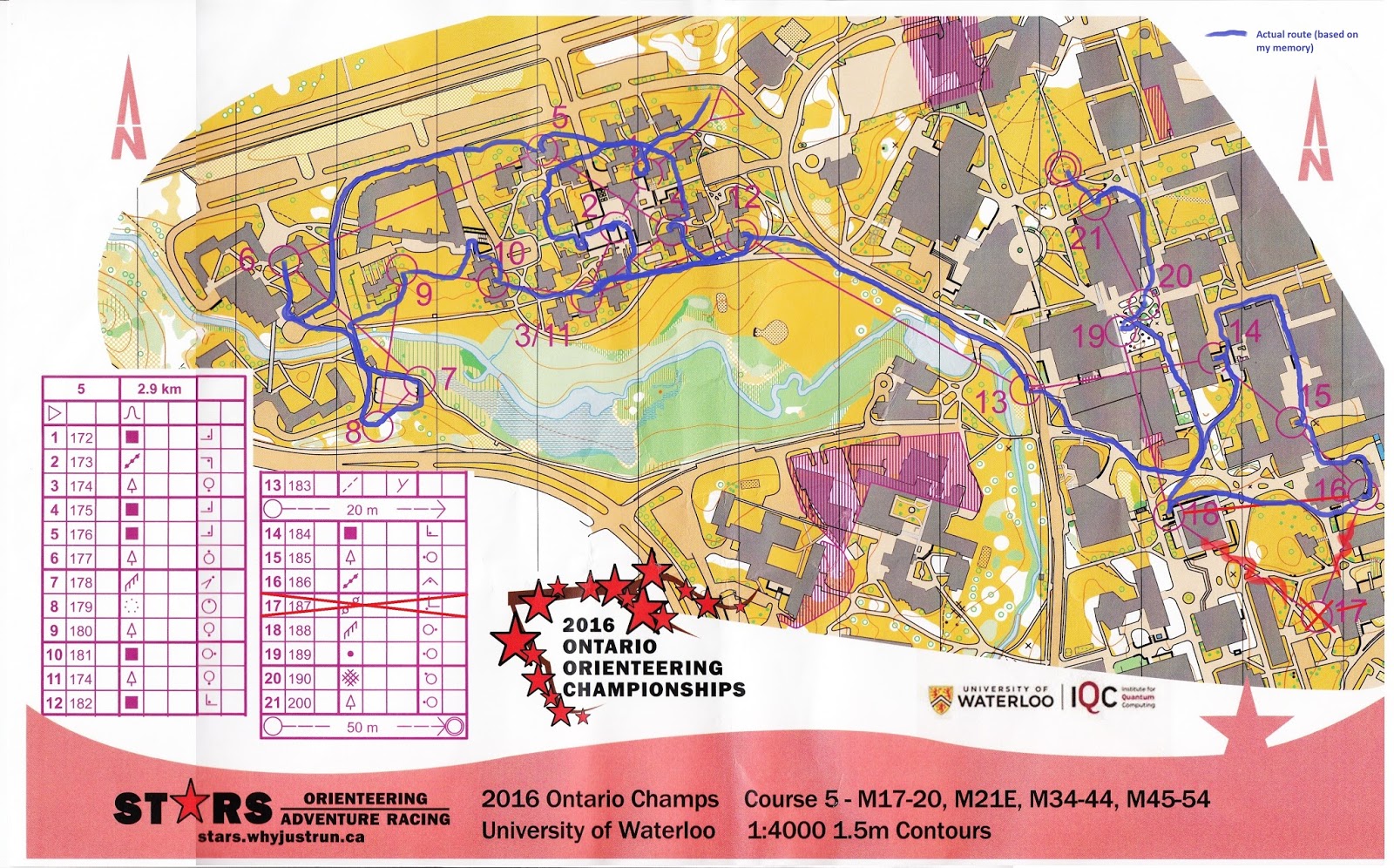

...and here is my GPS record. I think they virtually match exactly.
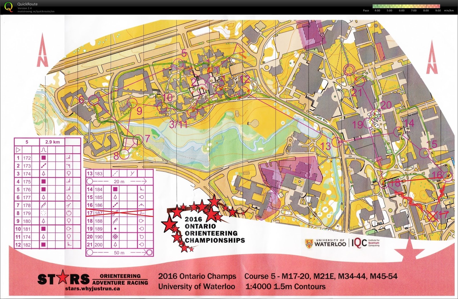

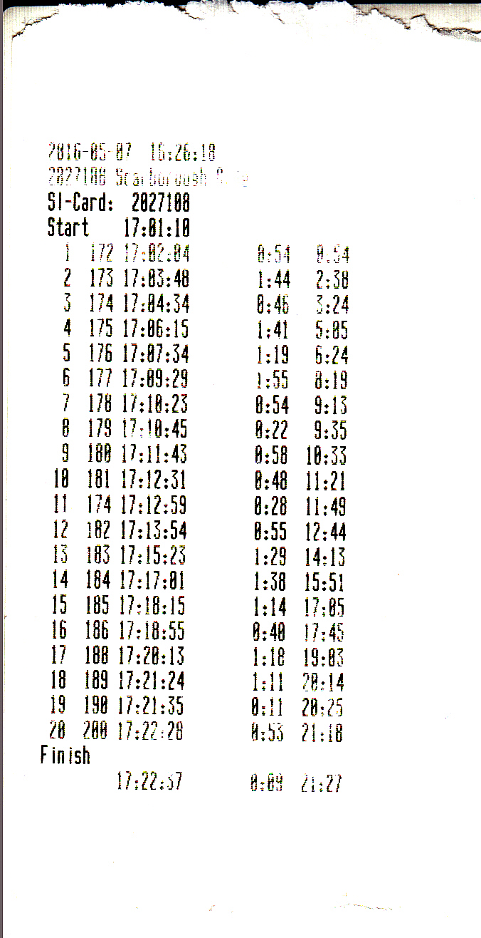
The fastest person finished in 16 minutes, though.

Here is the video on the sprint:


After the sprint, Jan guided me to his home in Toronto. He showed me an area that I had never been. We got some good food, and I could stay at his place for a night.

Long

Seeing that I could handle 10 km course last time in Cincinnati, I decided to take the M21 course, which is ~11 km long. The map, Mono Cliff, is at ~1 hour north of Toronto. I had an impression that maps in Canada are fun (read: complicated) to navigate. I hope I should at least enjoy the map.

At the start, we once again took a picture together. This time, the start was delayed for >40 minutes because course vetters came back late.


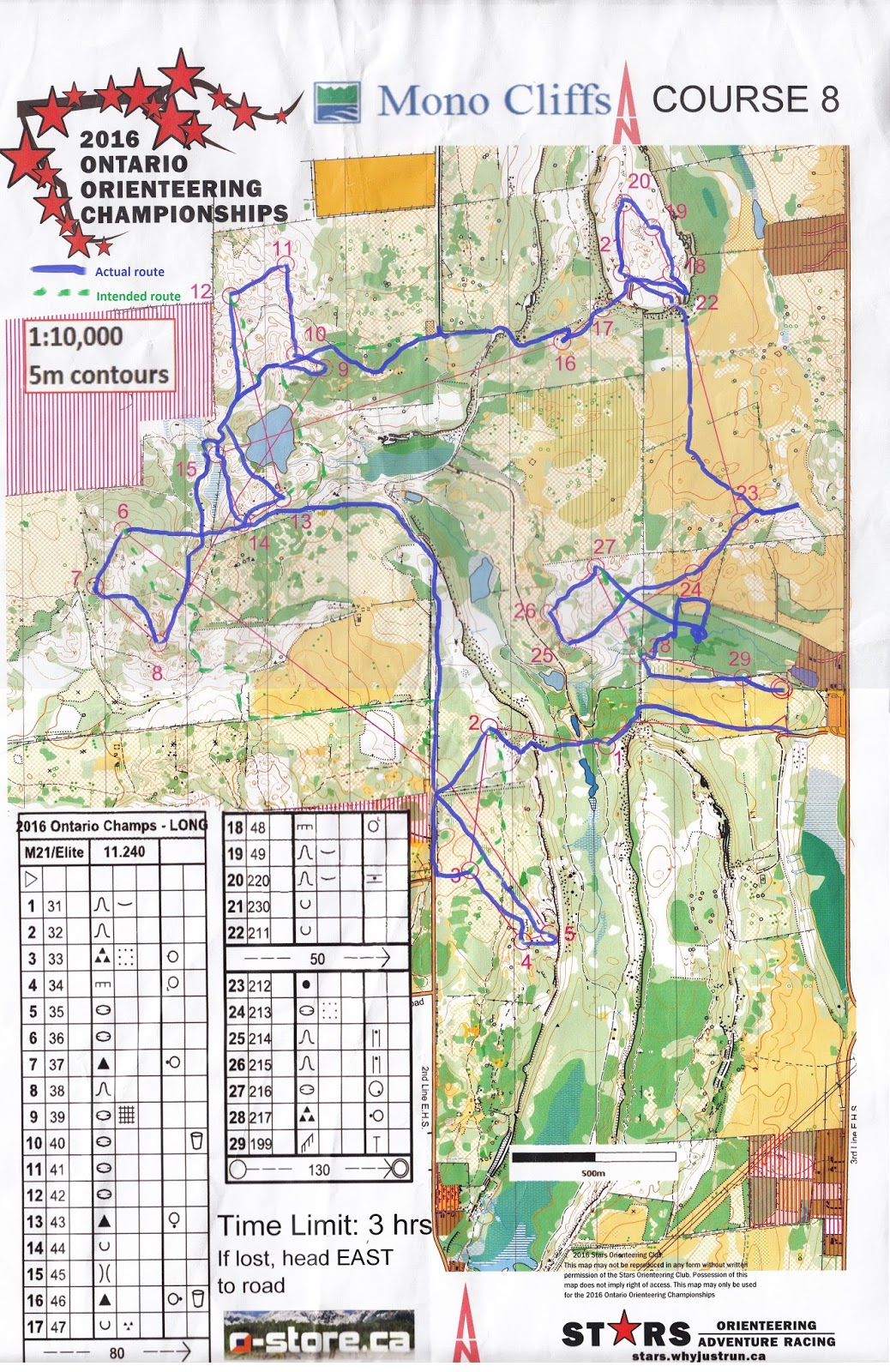
Here is the map. It was not as complicated as I thought. Still, at some local areas, there were still some navigational challenges. The course seems to have many short legs in the complicated area, and then one long leg to go to a new area.
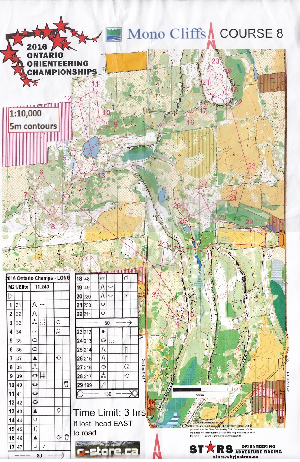

It was a good warm-up to Control #1. When going to Control #2, a girl asked me what to do if the control punch did not beep. I told her to use the spare mechanical punch and report the faulty control after completing the course. Then, I moved on.

I feel the first big mistake when going to #6. I was thinking of taking the more direct route through the open land, but I failed to find the path that led to this open land. Thus, I just went for the less desirable plan: run through the trail, but I still needed to climb hills twice to get to #6. Not a good route choice for me.

Then, to #13, I failed to get back to the trail as early as possible, and I failed to see that the path east of the lake is a better route choice.

At #16, I started to feel tired. From that point on, I felt that I could only walk. This set up some of the biggest mistakes happened in later legs.

To #18, there were two cliffs that were so deep that there were ribbons to forbid people to pass through. The hilltop between #17 and #22 is quite an interesting area.

Then, I felt that #23 was truly my first big mistake. Even I could locate the large and shallow depression with a man-made object on the open field, I was lost when I went downhill. It took me a long time to realize that I overshot.

Later, there were a final rounds of short legs, which I thought I navigated through them well just because I walked. In fact, overall, I thought I did fine for those technical short legs. I still had a few smaller mistakes (e.g., when approaching #7, I overshot), but I did not feel fatal.

However, I could not believe that #28 took me so long to find. It was the kind of mistake that I had not made for a while: circling through an area several times, but I still could not find the control. I thought I could use the fence to guide me to the control, but later I found that I went to the wrong fence. I tried to find the right fence, but was not successful. I also tried to use the stream to guide me to the control, but it did not work, either. Finally, I just wanted to overshoot to the open area, so that I could backtrack to #28, and found it. It took me >30 min to find this, which was unacceptable in my standard. If I did this leg again, perhaps I should trust my ability to read contours?

Here is my hand drawn route:

Here is my GPS record:


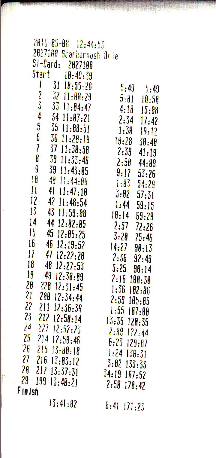
I barely finished within 3 hours. I felt that I could finish this within 2 hr 15 min if I felt well.

Finally, here is the video. If I did not make such big mistakes, I should have the whole course taken.


Summary

Despite the negativity of my performance in Toronto area, I still enjoyed the orienteering courses in these three days. The maps, while not as complicated as I thought, still offer enough navigational challenges that I considered fun. I still felt that these 10 hours of long drive were worth of my time.

Monday, June 6, 2016

16-hour layover in Zurich, Switzerland

The unexpected trip

One morning, I received an email saying that I got a job interview in Hong Kong. While I was excited, I knew I might need to spend a lot of money to come back, since I had to buy tickets at the last minute, and end of May was probably considered as high season for air tickets (some students still need to travel back home after the end of an academic year). Upon the initial search online from kayak.com, I found a ticket that costs only USD 1,000 from SWISS, which looked quite inexpensive to me. However, the route included the first flight to Zurich for 8 hours, having a long layover, and then another 11 hours of flight to Hong Kong. I checked with my frequently-used travel agent in Detroit on conventional flight routes (i.e., direct flight to Hong Kong, 14 hours, by Cathay Pacific or United Airlines), and none of them were <USD 1,000. Since (A) I had never been to Europe before, (B) a connection in Europe is even cheaper, and (C) the layover is all in the daytime, I thought it would be a good idea to make a one-day trip in another continent. I know that my passport does not need a visa to visit most (if not all) countries in Europe, so this one-day trip can work out.

Thus, I confirmed the ticket. My plane left Chicago at 2:45 pm (local time), arriving at Zurich, Switzerland at 6:40 am the next day, having some fun in Zurich until the second flight that left at 10:45 pm, and arriving in Hong Kong at 4:30 pm the day after.

At the airport

When the flight descended to Zurich, it was overcast, but snow-capped mountains could still be seen. I thought: with the lakes around this area, this looks like Seattle in the U.S (or Vancouver in Canada).


After the arrival, I had to cross the immigration check. I found that people with passports from European Union have a special line for them. After half an hour of queuing, I walked through the baggage claim, with nothing to claim, since my checked baggage could go through Switzerland to Hong Kong. I only had a backpack for these 16 hours.

Public transport is across the airport. There is a travel info center, where I could buy a one-day Zurich card. It costs CHF 24 (I could pay USD 26), and it can be used to travel to Zurich downtown, and one fare zone surrounding it, without additional cost. The airport itself is one fare zone from downtown. Moreover, it could be used for museum entry, which is mostly free, while some has discounts. Sadly, I went there on Monday, when most of the museums were closed. I still used the card to travel around a lot, though.

A regional train (S-Bahn) in Zurich. The screen shows the next few stops and their estimated time of arrival.
The train only took two stops to go from the airport to downtown, which is the train station. Some of the platforms are on the ground, while others are underground. Most of the times, buying the ticket is under honor system. I did not encounter anyone checking the tickets at all. However, according to Wikitravel, the penalty is heavy if you are found that you do not have the ticket.

Swiss National Museum - closed on Monday
Uetilburg

Next to the station, there is the Swiss National Museum that I hoped to visit, but it is closed on Monday. Thus, I walked along the river to examine the city layout. Zurich is the largest city in Switzerland. Yet, the city did not look big to me. It is difficult to find buildings that have more than 10 floors. Perhaps this is how people live in Europe.

After playing with Duolingo for two years, I think I had the ability to guess the texts in Spanish and French. I did not get to German, which was what I needed here. In this trip, I could still decipher some words in German, like Bahn=train, Bahnhof= train station, and Bahnhofstrasse (the main street in Zurich) = Station Street. "Bahn" is everywhere in Zurich. On the ground level, there are many streetcars (trams) that are also called Bahn. It was a delight for me to figure out what train to take.

My first plan was to go to a hill called Uetilburg. There is a train going there, from an elevation of ~400 m in the city to ~ 800 m at the last stop. From the stop, one may continue to hike up to a hotel with an observation tower. There were also several hiking trails. One could already find a great view of Zurich city and the large Lake Zurich from the top. Farther away, the snow-capped Swiss Alps could be seen.


I went for a short hike to find a geocache. The trails nearby were pretty steep, but guardrails and chains were there to protect people from falling. It seems to me that there would be a lot of fun to hike in Switzerland!

Lunch time

On the way back, I went to a bakery to buy and try a pastry. I did not eat it until in the evening. It costs ~ CHF 3-4. When I was at the airport, I went to Starbucks to see the price of a mocha. It was almost twice the price in the U.S. Later, when I checked the prices in Burger King at the train station, the same pattern of twice the U.S. price was also observed.

I saw several grocery stores called Coop - at the airport, at the train station, and on Bahnhofstrasse. Some of them looked like a supermarket (grocery stores much smaller than Walmart). Another one looked like a to-go food court, selling only food for lunch. The one on Bahnhofstrasse is like a department store (like Macy's), selling all kinds of clothes and having a food court on the top floor. I got a lunch there, seeing that I could use the restroom there. Most of the public restrooms (WCs) need CHF coins to use, which I did not have. Just ordering half rice and half meatballs with sauce, it already cost CHF 10. Yes, the price in Zurich was like doubling the U.S. price for everything.

After lunch, I checked the price of chocolate at this Coop basement. Some of the cheaper ones were ~CHF 2-3, while those in boxes could go up to CHF 10-15. What makes them so different?

Around Lake Zurich

In the afternoon, I went to the river and took a river and lake cruise. Zurich card covered the cost. I felt that I wanted to sleep, but I could still see the river and Lake Zurich when I tried to keep my eyes open.


There were several ferry lines on Lake Zurich. The fares are like the trains, which depends on number of fare zones crossed. On the lake, I could find the familiar mallards, but there are some ducks that I had never seen, and big white birds that are probably swans.


I was tired and my brain was not functioning. I found a large building with historical architecture. Thinking it must be a museum, I went in and being asked what I was doing. After several back-and-forth responses, I found that I was actually in an office building!

Altstadt (Old Town)

I walked back to the downtown area, where a large part is the historical Altstadt (Old Town). There are several churches in this area that are worth visiting (e.g., St. Peter's, Fraumünster, and Grossmünster). They looked huge and old.

Interior of Fraumunster
Grossmunster

The clocktower of St. Peter's
I walked through the narrow streets that only allow pedestrians.


These two pictures compare the residential area and the tourist area of Altstadt

There is a cable incline train (Polybahn) that moves people to an university area.


At this point, I found that I had not seen places for charging phone battery for a long time. Before even getting to the issue that the plug in Switzerland is different from the U.S., I found that a lot of public places do not have power outlets at all. I saw the first power outlet later in the afternoon (like 3 pm). Yes, it did not matter, since I did not have an adapter. I did not see any USB charger throughout the Zurich trip. This is good to take note of if I come to Switzerland again and use the phone often.

There is also a challenge in using free Wifi outdoors. In Zurich, to use free Wifi, one needs to provide the phone number, but visitors outside Switzerland do not have one. In this trip, I only found that Starbucks has a way to get around the phone number, and only had internet access in Zurich when I was near Starbucks.

I was happy to visit one Swiss gift shop that has many creative toys. The manual music box that can be customized is one of them. I think each of these products is also an art.


I walked up the small hill of Altstadt called Lindenhof, which provides another view of Zurich. I saw several people playing chess outside.


Main station (Hauptbahnhof, HB)

This is the transportation hub of everything in Zurich. Long-distance, international trains can be found on the ground floor.


Below the ground floor, there are many underground shops. I peeked the Asian restaurants to see if there are any differences in interpreting Asian food between the U.S. and Switzerland. I was not sure. This place looked like Panda Express in the U.S., but the food served seems different to American Chinese.


One more floor below, there are many regional trains. Many goes to suburbs of Zurich, and some goes out of Zurich (e.g., S-Bahn).

Back to the airport

It was 8 pm. I should buy some chocolate before heading to the airport. When I went to the Coop department store, there was already a guard gesturing that the shop was closed. Argh! I forgot from the travel guide that Swiss people close shops early. Thus, I caught a tram back to the main station, knowing that shops there are the exception of closing at 8 pm.

It was still bright at 8 pm in summer! Zurich has a latitude close to Seattle, WA, US
After buying a few package of chocolate in a supermarket called Migros, I got on this train back to the airport.


It is interesting to find that at the airport, I went through first round of passport control and baggage scanning, walking through several terminals, and getting another passport control again. I guess this is how Switzerland deals with local and international flights in one airport.

Afterthoughts

It was rare for me to sleep at least 4-5 hours on the plane before waking up. The night I got back to Hong Kong, I had a wonderful sleep. It seems that having a day trip in Europe helps overcoming jet lag!

(This later proves untrue, since I did not sleep that well in the next few nights)

I still feel that if the air ticket that makes a stop in Europe is as expensive as a direct flight, I may consider doing such bonus trip again. Perhaps I would allow myself staying there for one more day.

Concerning Switzerland, I sense that the best of the fun would be outside Zurich. Upon some research, in about 2 hours of train from Zurich, I can get very close to the lakes and Swiss Alps.

(One of the research sources: Amazing Race, Season 3, Ep. 8 : Rheinfall, Zurich, Grindelwald)


Monday, April 18, 2016

Apr 1-3, 2016 Flying Pig Orienteering Championship XX

Flying Pig Orienteering Championship is an annual national orienteering event in Cincinnati, OH area. This year, I signed up all three races. Friday was a sprint course, which is supposed to be short and quick. For M21 (i.e., men open), Friday course was only 3.1 km. Both Saturday and Sunday courses were classic (or long). I usually signed up for a course one level lower than M21, since I felt long courses were too long for me. This year, however, I signed up M21 long courses for both days. Both of them were almost 10 km long.

On Friday, I drove almost 4 hours to the Friday sprint event. Few months ago, I learned that I can borrow GoPro headcam from the university library. Thus, I borrowed one to take video record.


Friday Sprint - Miami University - Hamilton Campus

I was in a rush when I got to the event center. I was already late, and the start was going to close soon. I did manage to put my GoPro camera and get the approval from the organizer. However, I was unfamiliar with the headcam. I pressed the button to take a picture instead of taking the video. Thus, I did not have a video record for the sprint, which is reasonably short enough for watching.

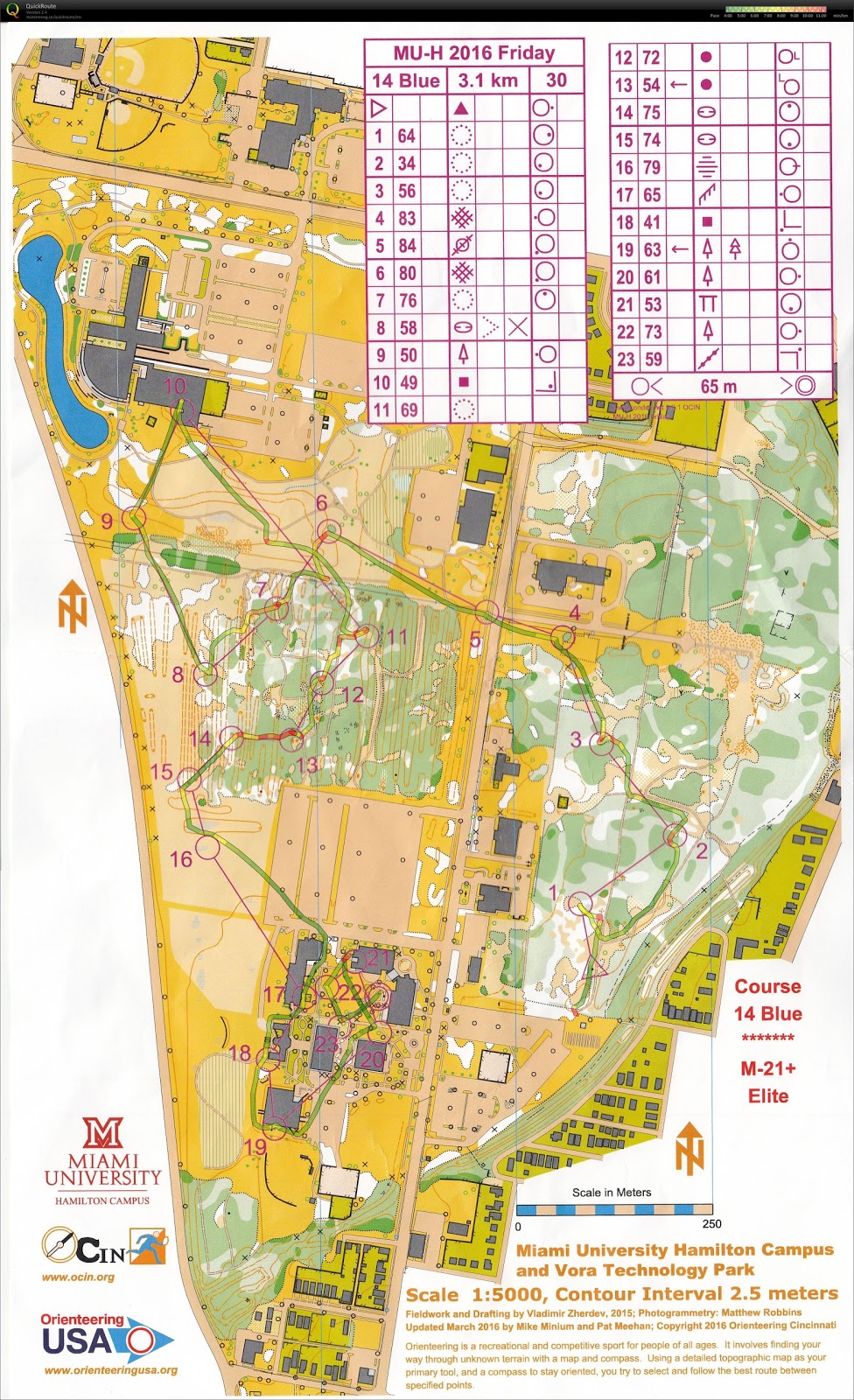
Nevertheless, I had the GPS watch record. There was not much to say about this course. Most of the navigation was easy. Controls #6-#15 were quite fun to go through, since this forested area has a lot of man-made trenches. 


Zoom-able map

I did take a video of the campus area, where the last few controls were located:


Saturday Classic - Miami Whitewater Forest, Harrison, OH

On Saturday morning on the charter bus that brought competitors to the start, I met Rob Minto from ICO. Rob has the whole family coming for orienteering, and we meet often when there is an orienteering event in Indiana. Rob told me that this was the best map in Cincinnati area. Before this competition, I found this map online to get an overall idea of the terrain. It gave me a typical feeling of re-entrant (gully) system. It is hilly, but navigation should not be difficult. Yet, Rob said, "you will see".

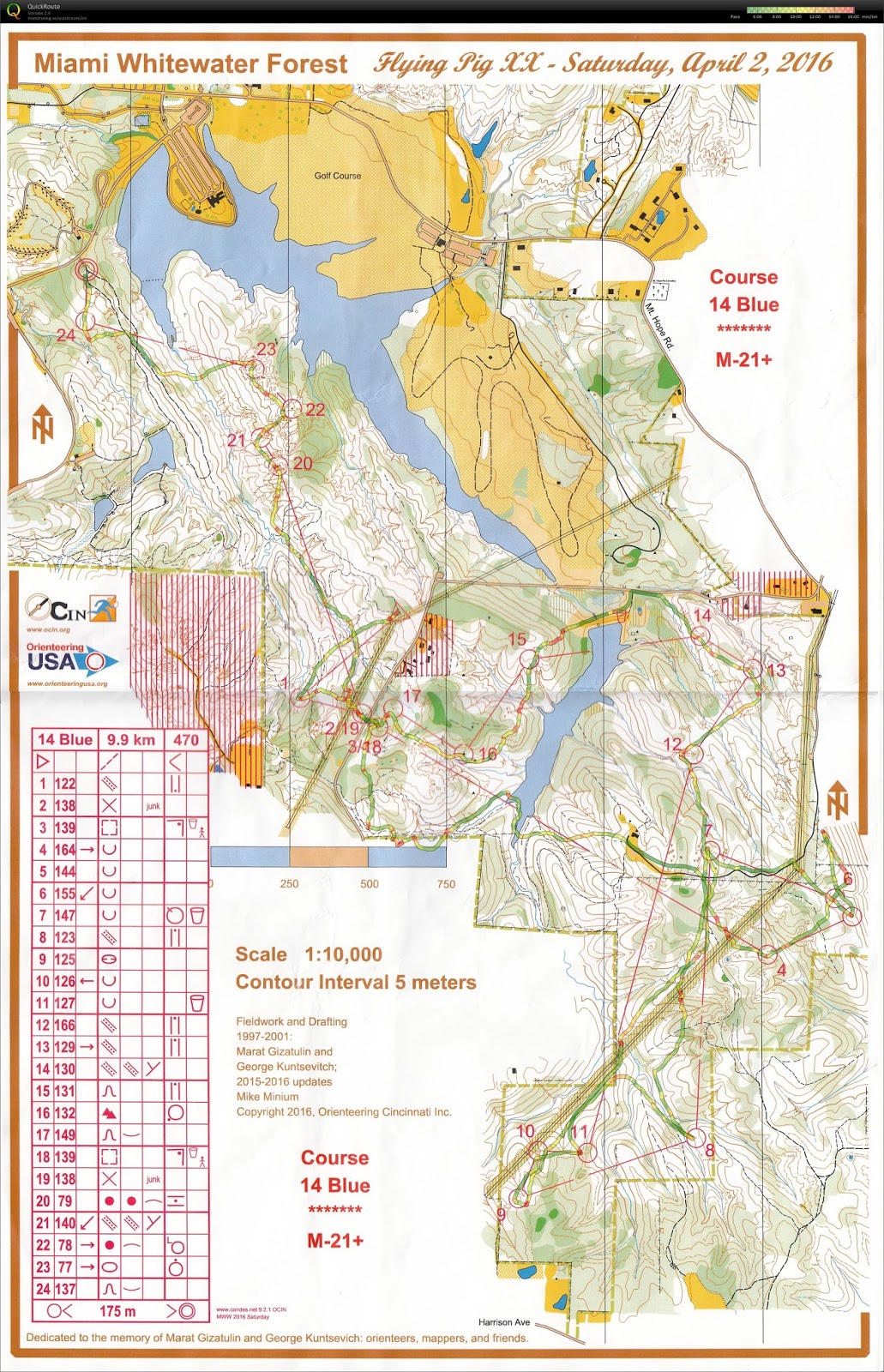
After doing the entire course, I understood what Rob meant. I was somehow elated, even though I did not win. The entire course is as follow:


Zoom-able map

I also have a video of the course. However, the battery of the headcam lasted only ~1:30:00. I only had a video up to Control #19. The video with the route can be found in this link.

Alternatively, this:


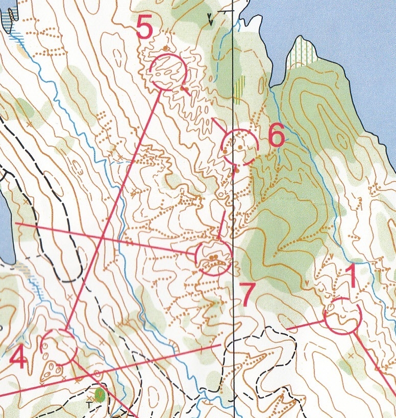
I struggled at the beginning. At the start, it took me 10-20 seconds to find the start triangle. Since there were 3 paths at the start, I could not walk until I found where I was. Then, the long leg to Control #4 , and then Control #5, were terrible. I thought I went east, but I actually went south and got out of the map. After this 90 degree mistake, I tried to take the safe route for this leg. Then, towards Control #5, I tried to aim off to the south to find the re-entrant and then went north. However, I had compass problem again. I still went too far north, hitting Control #6 first and did not realize that at first. I would even say this was a parallel error because I did hit a re-entrant, but it was the one north of what I needed to find.

After Control #5, however, I felt that I was in control of the course. Even though the decision was not perfect, I executed the route that I planned.

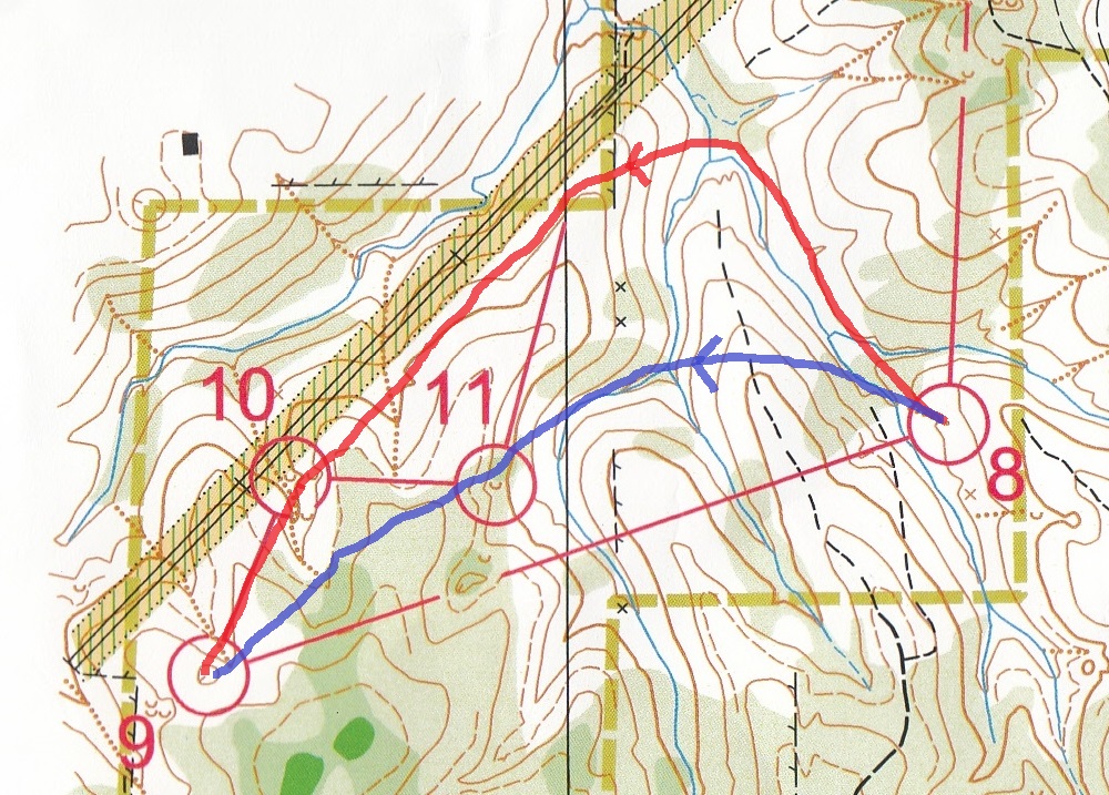
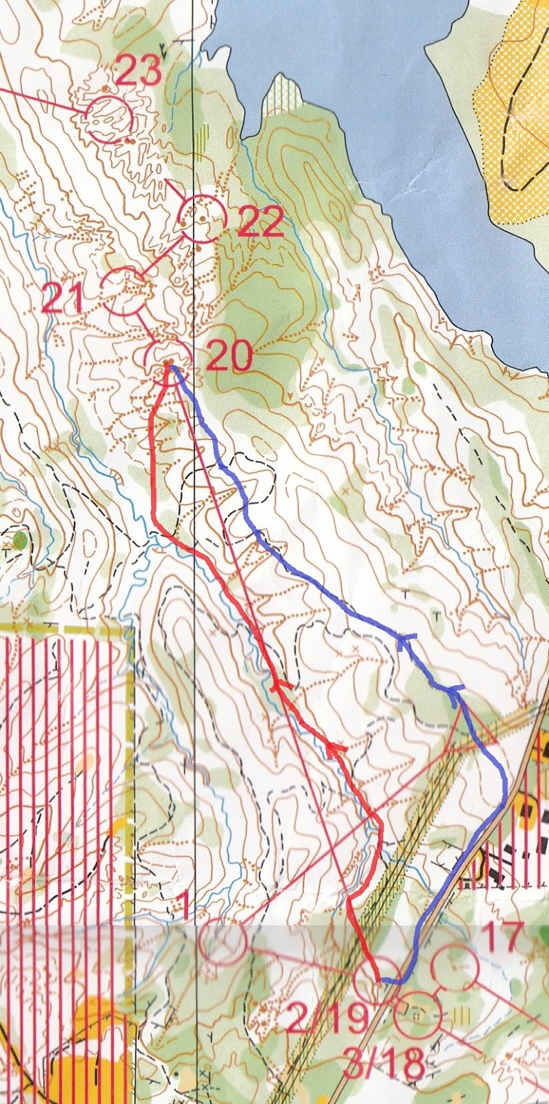
To Control #9, I already planned beforehand that I would rather run a more indirect route to reduce climb and reduce navigation uncertainty (red line). However, after the race, I was convinced that I could do one more climb with moderate uncertainty in navigation, while increasing the directness of the route (blue line). Some people did take the most direct route and climbed hills three times.


At Control #9, Maricel from CAOC caught up on me. He is one of the fastest orienteer in that club, and he started 16 minutes later than me. I hope I would not see him early, but I know this is difficult for me to avoid. He pointed me the location of the depression for Control #9, then he ran away. I knew my way to Control #10, since I saw Control #10 first. Then, I saw that Maricel did not run to my direction. When I went to Control #11, I saw him again. From the direction he ran, he clearly missed #10. I told him, with some reservation, "you missed the last control!" However, he did not hear me and ran away. Perhaps he knew what he was doing, so I did not yell at him any further. After all, I should probably not help if I was serious to the competition.

This course has several long legs. Besides the miserable Control #4, Control #8, #12, and #20 were also long. I tried to be safe when tackling long legs.

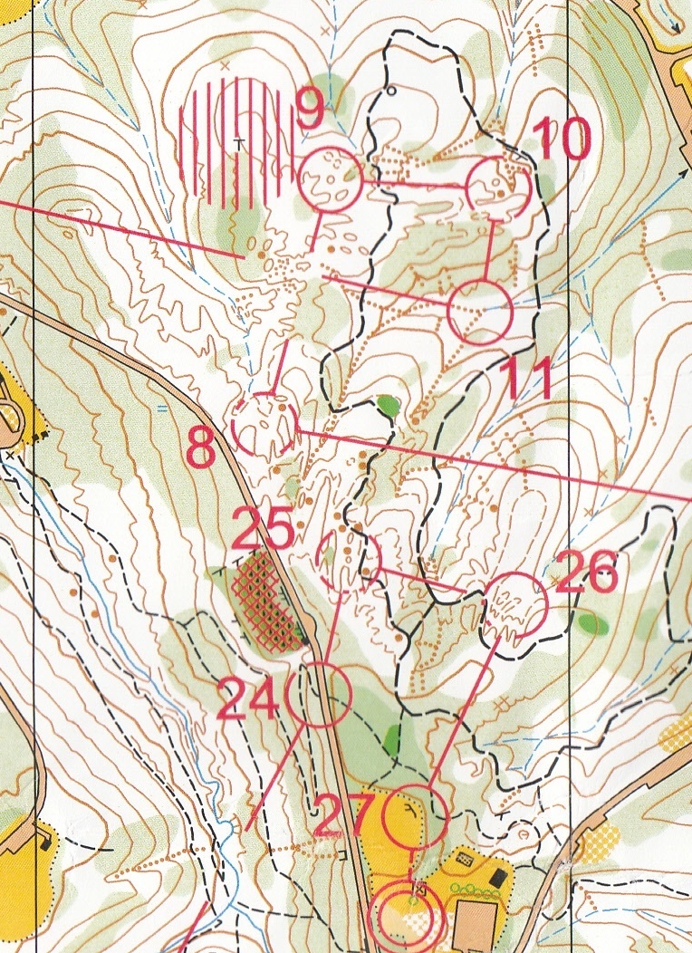
I thought Control #20 was fun enough (later found that using the trail east of the stream was a better choice than running along the stream), but the next three controls reminded me what Rob said. The terrain at these three controls is complicated, making me excited!


After the completion of the course, I looked forward to the competition the day after. I also checked the result, and found that Maricel did miss a control - the one that I yelled at him. Even though his time was the fastest, his result was invalid due to mis-punch.

Before leaving for the day, I bought a pair of orienteering shoes for $20. The heel of one of my orienteering shoes tore off, and it was time to find a replacement. I could not believe that I found such a cheap pair of shoes!

Sunday Classic - Miami Whitewater Forest - West

On Sunday, I thought I had a charged GoPro camera because I charged it the night before. However, before starting the Sunday course, I found the headcam was out of battery. Did it turn on by itself due to internal impact? Anyway, I did not have the video for this course. Look like I should double check the battery of the headcam next time.
More fun navigation happened today. After the run, I found out I made a lot of decision errors. I was aware of the options, but I still chose the wrong one. I also felt that this course was more on navigation than route choice.


There were still some route choice problems (e.g., Control #1, #8, and #12). I made bad choices on all three. For #8 and #12, I had thought about using roads -- longer distance but can do mindless running. However, I also thought that I would not run fast anyways. Why not taking a more direct route. After checking other people's route, I realized that I was wrong. Using roads were definitely faster.

The start was tricky. The best way to see the right route is not to run immediately, since the best choice was to leave the starting trail immediately. I was tricked at the start.

Controls #5, #6, and #7 were recycled from Saturday's course (#23-#22-#20 on Saturday)! It was still fun to revisit this area, though.


Then, there was an area with complicated terrain that we needed to visit twice: at the early half and at the end.


I did not quite know why I did not see control #16. I could not think of a better way to ensure a clean run for control #16.

In the later navigation legs, I found that I should take more direct routes to control #22 and #24.

Coming up

My friend from Toronto invited me to come to his place for an orienteering weekend. In a few weeks, I will do a sprint, a middle, and a long course around that area. Based on a sample map, there will be a lot of fun...

Sample map for Mono Cliffs near Toronto, for the long course